[ad_1]
 Getty Images
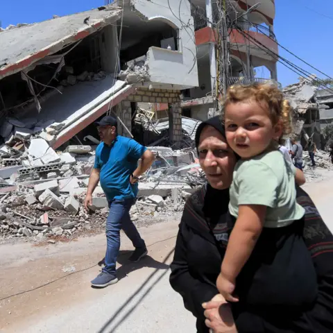
BBC analysis has uncovered the extent of damage caused by nine months of fighting between the Lebanese armed group Hezbollah and Israel.
Satellite photos, radar imagery and records of military activity show that entire communities have been displaced, with thousands of buildings and large swathes of open land damaged on the border between Israel and Lebanon.
Both sides have so far stopped short of all-out war, but evidence shows that near daily attacks have left communities in both Israel and Lebanon devastated.
The current fighting began when Hezbollah fired rockets at Israeli positions, which the group said was in solidarity with the Palestinians, a day after the outbreak of the Israel-Gaza war. Israel’s military offensive on Gaza was triggered by Hamas’s unprecedented attack on Israel on 7 October 2023.
 Getty Images
Data gathered by the US-based Armed Conflict Location and Event Data Project (Acled) and analysed by the BBC suggest both sides together carried out a combined 7,491 cross-border attacks between 8 October 2023 and 5 July 2024. These figures indicated that Israel has carried out around five times as many as Hezbollah.
The UN says the attacks have forced more than 90,000 people in Lebanon from their homes, with around 100 civilians and 366 Hezbollah fighters killed in Israeli strikes.
In Israel, officials say 60,000 civilians have had to abandon their homes and 33 people have been killed, including 10 civilians, because of attacks by Hezbollah.
Southern Lebanon building damage
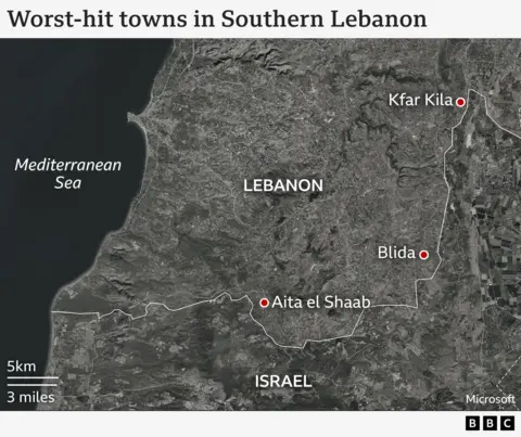
Analysis reveals more than 60% of the border communities in Lebanon have suffered some kind of damage as a result of Israeli air and artillery strikes. As of 10 July, more than 3,200 buildings may have suffered damage.
The findings were put together by Corey Scher of City University of New York Graduate Center. They are based on comparisons of two separate images, revealing changes in the height or structure of buildings which suggests damage.
The towns of Aita el Shaab, Kfar Kila and Blida appear to have been among the worst affected.
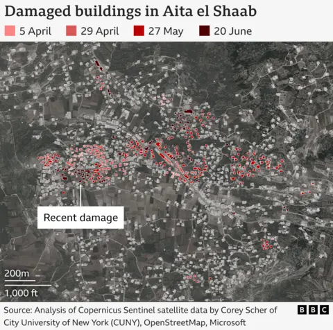
Aita el Shaab has been extensively hit, with at least 299 attacks since October, according to Acled.
Buildings along the main road of the town, including restaurants and shops have particularly suffered damage.
The BBC spoke to the mayor of Aita el Shaab, who described the town “as if it was hit by an earthquake”.
Majed Tehini said 17 people from the town have been killed in the Israeli strikes, including two civilians.
He left Aita el Shaab with his family immediately after the hostilities started in October last year, but he said he returned almost every fortnight, mainly to attend funerals.
“Every time I visit, I feel it has changed. The sight of the destruction is just terrible,” he told the BBC.
“The houses of Aita have become mere structures. The destroyed ones have been reduced to rubble. Those still standing are uninhabitable”, he added.
Mr Tehini recalled seeing the town destroyed in the past, mainly in the 2006 war between Israel and Hezbollah, but he says the bombs have caused much bigger destruction this time.
He explained that all the infrastructure has been damaged, including the electrical grid and the water supply system.
“Our house is still standing. But it’s just by appearance. It’s all ruined”. he added
Town centres damaged
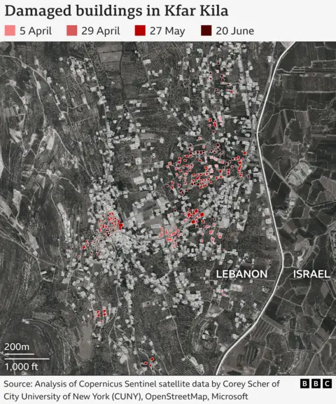
More than 200 attacks targeted Kfar Kila, damaging several supermarkets and service shops in the central area of the town, according to Acled
Blida town has also been hit at least 130 times since October, damaging several buildings as well as a pharmacy, according to Acled.
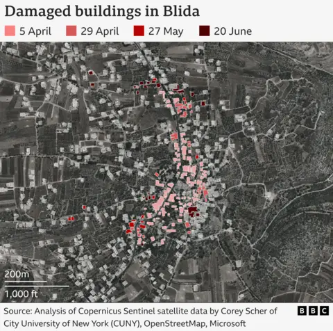
The damage has been focused on the central part of the town where the main services, shops and facilities are located.
Dr Burcu Ozcelik, a senior research fellow for Middle East security at Rusi said Israel is targeting towns in the border area because these are areas where it says Hezbollah is deeply entrenched.
“Israel believes that they have sufficient documented evidence that there are a network for fortifications and tunnels in the vicinity of homes.”
She said Israel is targeting this area to send a message to Hezbollah that they “should not be there”, but believes Hezbollah would find it unthinkable to evacuate.
“The US has been trying to find a middle ground, such as getting Hezbollah to withdraw four miles from the border. Hezbollah has rejected this.”
The Israel Defense Forces (IDF) told the BBC it has carried out strikes against military targets to “remove the threat posed by Hezbollah to Israel, its citizens, and their homes”.
Israel’s fire damage
Across the border, buildings in northern Israel have also been destroyed by strikes from the other side.
Israeli media has reported more than 1000 buildings have been damaged since October. The IDF and the Israeli Ministry of Defence were contacted, but did not want to comment.
But it’s the destruction of land which has been significant here.
The BBC has used data supplied by Dr He Yin at Kent State University to examine the amount of land damaged by the huge wildfires that have been sparked by the cross-border attacks.
Dr Yin processed data from publicly available satellite images filmed in near-infrared and shortwave infrared (which are outside the visible spectrum) to identify areas that are suspected to have been burned.
This was checked against satellite photographs and local news reports.
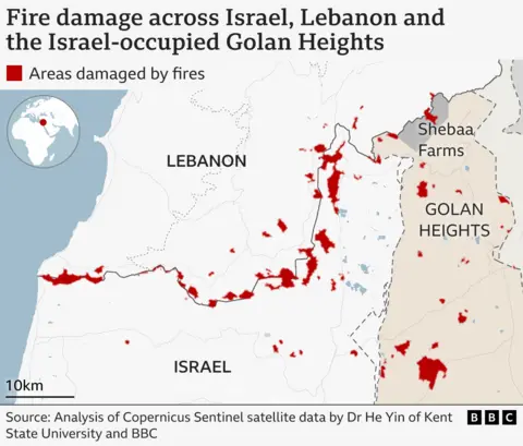
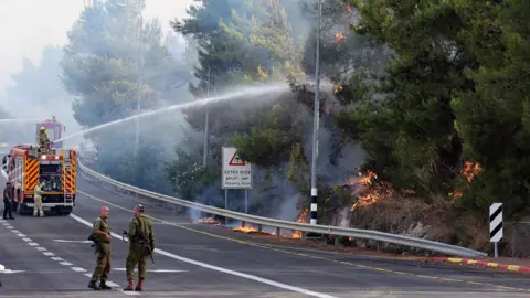
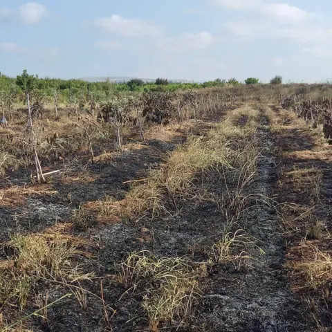
Huge amounts of land have been burnt in both countries, but the BBC estimates that Israel and the Israeli-occupied Golan Heights have been hit hardest, with around 55 sq km (21 sq miles) of land affected, compared to 40 sq km for Lebanon.
Some recent estimates by Israel’s Nature and Park Authority have put this figure as high as 87 sq km.
The pattern of damage shows that many of the areas burnt are set back from the border, which reflects the use of large numbers of unguided weapons by Hezbollah. These have been fired at civilian areas and military bases which aren’t immediately next to the frontier. If Israel’s anti-missile Iron Dome system detects that missiles will not land in populated areas, it does not intercept, leaving the missiles to land in the open.
It results in extensive damage to agricultural land, farmland and forests. Dr Ozcelik said that’s intentional on the part of Hezbollah.
“You could attribute the fires to the types of weapons that are being used but part of that story is that Hezbollah seeks to create chaos and a level of insecurity among the Israeli population which creates a pressure point on the Israeli government.”
The scale of evacuation is “unheard of in the Israeli context,” Dr Ozcelik added.
The scale of the damage is illustrated by images of the settlement of Katzrin in the Israeli-occupied Golan Heights. A huge swathe of burnt land, larger than the settlement itself, appeared after a barrage of rocket fire in early June.
About 20 miles (30km) to the north east, lives Tzahi Gabay, a farmer and a member of the local response team.
He is one of the few Israelis to remain in the border area. His wife and two children, aged 5 and 7, fled their town of Kfar Yuval, which lies just metres from the frontier, and have been living in a small hotel room for the past nine months. Mr Gabay sees them only once a week.
 Getty Images
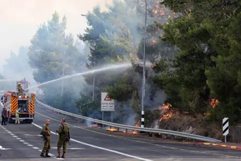
He has seen first-hand the fires that have been devastating huge areas of northern Israel.
“Fearing the rocket attacks, people neglected the vegetation and it dried up during the spring. Every UAV [drone], rocket or missile that was fired immediately ignited enormous fires in the Galilee. The entire area was burning. We had to fight the flames, to put out the fires, to prevent greater damage to our fields, to our businesses”, he added.
 Getty Images
The fires are not the only danger.
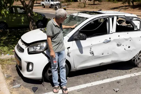
His neighbours, Barak and Mira Ayalon, were killed in January. They were having lunch in the kitchen when a missile blasted through their living-room wall.
Mr Gabay has known the family for years.
“We grew up together. Removing their bodies in that condition… People I knew well… It wasn’t easy,” he sighs.
While a small number of his town’s residents have stayed to keep their fruit trees alive, around 90% have evacuated, knowing theirs may never produce another harvest.
Hezbollah did not respond to a request for comment. But its leader Hassan Nasrallah said on Wednesday that the Israeli “persistence in targeting civilians” would push the group’s fighters to target new “settlements” with missiles and warned Israel that its tanks would be destroyed if they crossed into Lebanon.
And in a televised address on 10 July, he reiterated a vow to suspend his organisation’s attacks if a ceasefire is reached between Israel and Hamas.
White phosphorus
Most of the 40 sq km of land estimated by the BBC to have been affected by fire in Lebanon is close to or adjacent to the security barrier between the two countries.
Lebanese Agriculture Minister Abbas Hajj Hassan told the BBC that 55 towns across the border line were affected by the fires caused by Israel.
He accused Israel of using white phosphorous among other ammunition and of wanting to render the area barren and abandoned.
White phosphorous is a chemical substance that ignites immediately on contact with oxygen. It sticks to skin and clothing and can even burn through bone.
The international campaign group, Human Rights Watch, has verified the use of white phosphorus over several populated areas in southern Lebanon, including al-Bustan.
It says Israel’s use of white phosphorus is “unlawfully indiscriminate in populated areas”.
The IDF disputes this, saying the use of white phosphorus shells to create a smokescreen “is lawful under international law”. It says these shells are not used in densely populated areas “with certain exceptions”.
Concerns over escalation
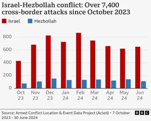
According to the Acled data, the intensity of hostilities between Israel and Hezbollah has not reduced since 8 October, with even a slight increase in the number of attacks between both sides in recent months.
Dr Ozcelik said there are concerns that any further escalation in fighting could trigger an all-out war, which could even draw Iran into a direct confrontation with Israel in defence of Hezbollah.
But, in a note of optimism, she said she believes both Israel and Hezbollah are trying to avoid that eventuality.
“Both sides are being quite calibrated in their approach across the border to avoid a misfire or a human error or a miscalculation.”
Additional reporting: Carine Torbey, Michael Shuval, Joya Berbery, Daniele Palumbo
[ad_2]
Source link freeslots dinogame telegram营销


