[ad_1]
 BBC
BBCA fresh bout of heavy rain is likely to cause more flooding across parts of England badly hit by downpours earlier this week, the Met Office has warned.
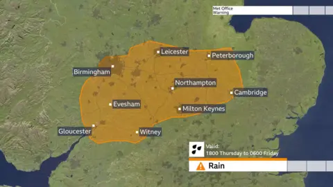
A more serious amber warning has been issued for some areas in the midlands and central England, forecasting further flooding and travel disruption as a month’s worth of rain could fall.
The new warning is in place from 18:00 on Thursday until 06:00 on Friday, while existing yellow rain warnings remain in place for other parts of England, Wales and Northern Ireland.
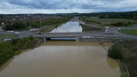
Areas in central and southern England are still recovering from days of downpours over the weekend and Monday that left roads and fields submerged, rail services disrupted and rivers overflowing.

The Environment Agency has 27 flood warnings and 69 less severe flood alerts in place across England.
Some areas covered by the new amber warning could see 30-40mm of rainfall in three hours or less, and perhaps 50-60mm or more in around six hours, the Met Office says.
Places under the amber warning include Oxfordshire, Leicestershire, Bedfordshire, Gloucestershire, Cambridgeshire, Buckinghamshire and Worcestershire.
Matt Taylor, BBC lead weather presenter, said that some places within the amber warning area could see close to a month’s worth of rain overnight and, given how saturated the ground is following the rain already seen this week, existing flooding could be exacerbated further.
More travel disruption is likely and rivers will continue to rise after the rain clears.
Some areas covered by the warning have already experienced record September rainfall this month. Parts of Bedfordshire and Oxfordshire, in particular, have seen over three times their normal September rainfall.
Yellow rain warnings that remain in place elsewhere are:
- For northern England east of the Pennines and north-east England until Thursday midnight
- A separate warning southern England, southern Wales and parts of the Midlands until 09:00 on Friday
- In eastern parts of Northern Ireland until 18:00 on Thursday
Less rain is forecast in areas under yellow warnings, but heavy downpours could still lead to flooding and transport disruption.
Rain is expected to clear later on Friday and the forecast is drier for the weekend, but forecasters say that a few showers cannot be ruled out, but not on the scale seen so far this week.
However, it will be colder for all and BBC Weather is monitoring the prospect of more wet, and also windy weather arriving later Sunday and into Monday.
Emergency services rescued 43 people from a holiday park in Northampton on Tuesday evening, after caravans were left surrounded by water from a nearby river which had burst its banks.
Areas including Buckinghamshire, Northamptonshire and Warwickshire were among the worst hit on Monday, the Met Office said previously.
Some places experienced more than a month’s worth of rain in a matter of hours over the weekend and Monday.
Football team AFC Wimbledon in south London said its pitch sustained “significant damage” after the nearby River Wandle broke its banks.
[ad_2]
Source link


